
Will It Rain? Monitoring Program Puts Crucial Info in Hands of Remotest Farmers
At a vegetable farm in West Africa, where the planting is done by hand, questions about weather boil down to the most urgent question of all: Will the rains be good or bad?
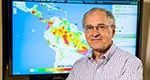
Princeton professor Eric Wood, a hydrologist who usually works with global data and computer models, visited the small farm an hour out of Niamey, Niger, in 2013. There, he spoke with the very people who would benefit from a new drought and flood risk monitoring system that he had created. Farmers in Niamey rely on their agricultural agents, and by extension Wood’s program, to tell them when the rains will come and how plentiful they will be.
“There’s a strong seasonal cycle of rainfall, coming from the south,” said Wood, the Susan Dod Brown Professor of Civil and Environmental Engineering. “They want to know, will they have good rains or bad rains, when will the rainy season start? They want to make sure the rains are there before they plant. If they plant too early, the seeds will die before they get established. These are people who live on a couple of dollars a day, maybe less. It’s very difficult for them to get new seed to plant.
“You travel to these places and you realize just how great their needs are for information to help them cope with water management problems. And you walk away thinking that maybe, well … you’re doing some good. It does give great satisfaction.”
Wood and his team of Princeton engineers have deployed their advanced drought and flood risk monitoring program for environmentally vulnerable regions like Niger and other areas in Africa and in Latin America. The program assimilates weather data that are plentiful but hard to analyze for those on the ground.